
Page 12 – Map 1
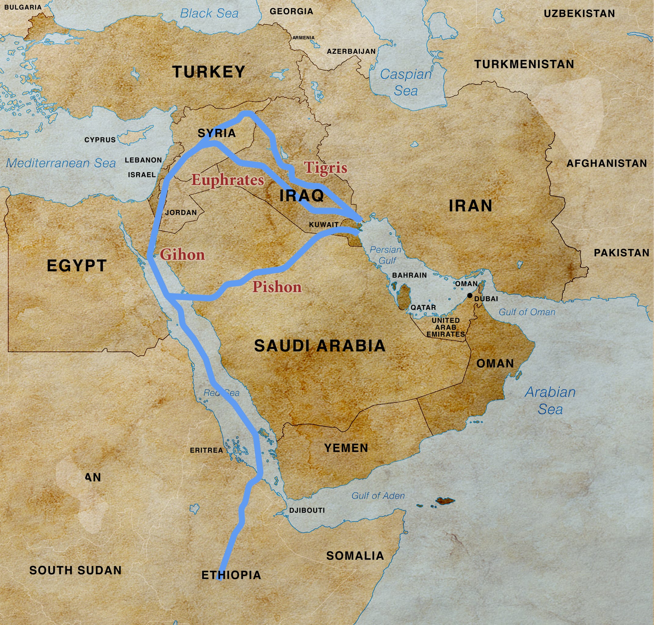
This map shows the location of the Euphrates, Hiddekel (Tigris), Gihon (Nile), and Pishon Rivers. These rivers defined the boundaries of the Garden of Eden. The Pishon is now a dried riverbed covered with sand, but it once crossed Saudi Arabia and ended at Kuwait.

Page 13 – Map 1
This map shows the lands east of Eden (east of Iraq) where Cain and his descendants would have settled. It includes Iran, Afghanistan, and Pakistan.

Page 19 – Map 1
The ancient land of Nimrod, the Tower of Babel, and the land of Shinar. Most of this territory today is southern Iraq.

Page 25 – Image 1
The seven-headed serpent Lernaean Hydra from Greek mythology.
Page 26
These are maps of the ancient empires of Bible prophecy: Egyptian, Assyrian, Babylonian, Medo-Persian, Grecian, and Roman. Countries that were under the control of the Babylonian, Medo-Persian and Grecian Empires will also be under the control of the Antichrist. The exception will be Jordan, which escapes Antichrist control.

Page 26 – Map 1
The 1st Head – Before its decline, the Egyptian Empire had some control or influence over Sudan, Canaan, Phoenicia (Lebanon), Syria, Libya, and Ethiopia.

Page 26 – Map 2
The 2nd Head – The Assyrian Empire expanded until it controlled the modern countries of Iraq (the core of its empire), major parts of Syria, southeastern Turkey, western Iran, Lebanon, the Northern Kingdom of Israel, parts of Jordan, Egypt, Saudi Arabia, and Kuwait.

Page 26 – Map 3
The 3rd Head – The Babylonian Empire controlled the ancient Mesopotamian region which encompassed most of modern Iraq, Syria, western Iran, parts of Jordan, Saudi Arabia, and Kuwait, southern Turkey, Lebanon, Israel, and part of Egypt.

Page 26 – Map 4
The 4th Head – Here are the boundaries of the ancient Persian Empire. Part of this land is today known as Iran. The Persian Empire covered portions of the continents of Asia, Africa, and Europe.

Page 26 – Map 5
The 5th Head – The Grecian Empire under Alexander the Great included parts of Europe, Africa, and Asia. It was the largest empire the world had seen up to that time.

Page 26 – Map 6
The 6th Head – At its peak around AD 117, the Roman Empire was one of the largest and most powerful in history. Its vast territory crossed Europe, North Africa, and the Middle East.

Page 42 – Map 1
This map shows the location of Islam’s two holiest cities of Mecca and Medina in Saudi Arabia.

Page 42 – Image 1
Mecca, Saudi Arabia – the black stone of the Kaaba is shown in the center.

Page 42 – Image 2
Medina, Saudi Arabia – The second holiest city in Islam. In this picture is the “Prophet’s mosque,” which contains Muhammad’s tomb.

Page 46 – Map 1
This map shows boundaries following Israel’s 1948 War of Independence with the countries of Egypt, Transjordan, Syria, Lebanon, and Iraq.

Page 52 – Map 1
The map shows the location of the Gaza Strip in the southwest corner of Israel, along the Mediterranean Sea.

Page 52 – Map 2
The map shows the location of the five Philistine-controlled cities in the Old Testament known as the Pentapolis: Ashdod, Ashkelon, Ekron, Gath, and Gaza. Ashdod and Ashkelon are not located in the area known today as the Gaza Strip. These cities are under Israeli control.

Page 56 – Image 1
The four colors of the Palestinian flag are the same colors as the four horses of the Apocalypse—white, black, red, and green (translated as pale in scripture, but the word is chloros in Greek, which is a shade of green).

Page 61 – Image 1
The crust, mantle, and core of the Earth. The Mohorovicic discontinuity is a boundary between the Earth’s crust and mantle.

Page 65 – Map 1
The Euphrates River is where the four demonic angels of Revelation 9:4 are currently confined.

Page 65 – Image 1
The Euphrates River is where the four demonic angels of Revelation 9:4 are currently confined.

Page 67 – Map 1
Bashan / Golan Heights is in northeastern Israel at the border of Syria. Moses assigned this land to the half-tribe of Manasseh.

Page 68 – Image 1
Bashan / Golan Heights is a lush area with plenty of water that comes from several sources, one of which is the Dan River at the foothills of Mount Hermon.

Page 68 – Image 2
The Dan River is fed by multiple springs that receive water from rainfall and snow that melts on Mount Hermon. Eventually the Dan River joins other tributaries and flows into the Jordan River.

Page 69 – Map 1
The Dead Sea (referred to as the Salt Sea in the Torah), borders Jordan to the east, Israel to the west, and the area referred to as the West Bank to the north.

Page 69 – Image 1
The Dead Sea (referred to as the Salt Sea in the Torah), borders Jordan to the east, Israel to the west, and the area referred to as the West Bank to the north.

Page 69 – Map 2
The Valley of the Passengers (Travelers) is a passageway between the mountains in Moab where travelers could cross into Israel near Jericho, north of the Dead Sea.

Page 79 – Map 1
Locations of Iran’s nuclear facilities (Bushehr, Natanz, Fordow, Arak, and Isfahan)

Page 98 – Image 1
Octagonal Dome of the Rock and al-Aqsa mosque (bottom center) on the Temple Mount in Jerusalem

Page 105 – Image 1
Bashan / Golan Heights, in the north of Israel. Bashan is one of the sites of the Gog of Magog War (Ezekiel 38-39).

Page 105 – Image 2
Bashan / Golan Heights, in the north of Israel. Bashan is one of the sites of the Gog of Magog War (Ezekiel 38-39).

Page 105 – Image 3
The Valley of Megiddo is commonly associated with the Jezreel Valley, which will be the location of the Battle of Armageddon. The archaeological excavation site in the center of the picture is Tel Megiddo, where many battles have taken place. This was once the location of a strategically important trade route between Egypt and Damascus. Tel Megiddo holds the remains of twenty cities, each of which were built over the remains of a previous city.

Page 122 – Map 1
Egypt, Libya, and Ethiopia, all located in Africa, will be seized by the Antichrist before he takes Jerusalem in the second half of the Great Tribulation.

Page 132 – Map 1
Israel is located between the Dead Sea on the east and the Mediterranean Sea on the west.

Pag 136 – Map 1
Turkey is the ancient land of Meshech and Tubal

Page 138 – Map 1
The Ottoman Empire at its peak in 1683

Page 147 – Map 1
Persian Gulf nations known as the Gulf Arab States – Iraq, Kuwait, Saudi Arabia, Bahrain, Qatar, United Arab Emirates, and Oman.

Page 155 – Image 1
Black basalt stones in the Bashan / Golan Heights

Page 160 – Image 1
Griffin vultures in the Bashan / Golan Heights

Page 161 – Image 1
Ancient megalithic structure in the Golan Heights known in Hebrew as Gilgal Refaim, or “wheel of the giants”

Page 164 – Image 1
The highly populated land of India, with 1.45 million active-duty military personnel and a population of 1.46 billion people.

Page 166 – Map 1
This map shows some of the routes for China’s Belt and Road Initiative.

Page 166 – Image 1
Chinese rail system used in the Belt and Road Initiative.